


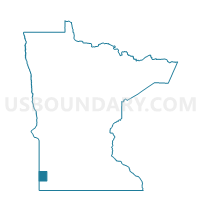
Altona Twp. Voting District, Pipestone County, Minnesota
About
Outline

Summary
| Unique Area Identifier | 603643 |
| Name | Altona Twp. Voting District |
| County | Pipestone County |
| State | Minnesota |
| Area (square miles) | 43.04 |
| Land Area (square miles) | 43.00 |
| Water Area (square miles) | 0.05 |
| % of Land Area | 99.89 |
| % of Water Area | 0.11 |
| Latitude of the Internal Point | 44.14766970 |
| Longtitude of the Internal Point | -96.38699980 |
Maps

Graphs
Select a template below for downloading or customizing gragh for Altona Twp. Voting District, Pipestone County, Minnesota


Neighbors
Neighoring Voting District (by Name) Neighboring Voting District on the Map
- Fountain Prairie Voting District, Pipestone County, MN
- Grange Twp. Voting District, Pipestone County, MN
- Lake Benton Twp. Voting District, Lincoln County, MN
- Troy Twp. Voting District, Pipestone County, MN
- Verdi Twp. Voting District, Lincoln County, MN
- VTD-precinct 16, Brookings County, SD
- VTD-precinct 4B, Moody County, SD
Top 10 Neighboring County Subdivision (by Population) Neighboring County Subdivision on the Map
- Troy township, Pipestone County, MN (289)
- Lake Benton township, Lincoln County, MN (241)
- Verdi township, Lincoln County, MN (206)
- Grange township, Pipestone County, MN (203)
- Fountain Prairie township, Pipestone County, MN (188)
- Union township, Moody County, SD (182)
- Altona township, Pipestone County, MN (153)
- Elkton township, Brookings County, SD (94)
- Ward township, Moody County, SD (66)
Top 10 Neighboring Unified School District (by Population) Neighboring Unified School District on the Map
- Pipestone Area School District, MN (7,718)
- Flandreau School District 50-3, SD (3,907)
- Elkton School District 05-3, SD (1,467)
- Lake Benton Public School District, MN (1,395)
Top 10 Neighboring State Legislative District Lower Chamber (by Population) Neighboring State Legislative District Lower Chamber on the Map
- State House District 22A, MN (34,781)
- State House District 20A, MN (32,187)
- State House District 4, SD (20,558)
Top 10 Neighboring State Legislative District Upper Chamber (by Population) Neighboring State Legislative District Upper Chamber on the Map
- State Senate District 22, MN (71,339)
- State Senate District 20, MN (66,816)
- State Senate District 4, SD (20,558)
Top 10 Neighboring 111th Congressional District (by Population) Neighboring 111th Congressional District on the Map
- Congressional District (at Large), SD (814,180)
- Congressional District 1, MN (644,787)
- Congressional District 7, MN (625,512)
Top 10 Neighboring Census Tract (by Population) Neighboring Census Tract on the Map
- Census Tract 9586, Brookings County, SD (3,746)
- Census Tract 9596, Moody County, SD (3,313)
- Census Tract 2010.02, Lincoln County, MN (2,801)
- Census Tract 4601, Pipestone County, MN (1,643)